Something a little different for Ballot Box Scotland today – looking not at election results past or present, but instead the process that surrounds drawing boundaries for those elections.
Fellow nerds may have noticed that the long-awaited review of Island Council boundaries entered the public consultation phase last week. Whilst most Scottish councils had boundary changes agreed ahead of the 2017 elections, proposals for the three Island councils were rejected pending the passage of the Islands Act. The ban on public bodies putting Shetland in a box – a provision plenty of folk, not least myself, have had lots of fun with – is the most well known aspect of that act, but it’s not the only one that involves maps.
Since STV was introduced for council elections in 2007, every ward has elected either 3 or 4 councillors. The Islands Act allows 1 or 2 councillor wards to be drawn in cases where they contain an inhabited island if it’s in the best interests of local representation, and so a review of ward boundaries is now taking place. This first stage only deals with those completely island based councils – Orkney, Shetland and the Western Isles. A later stage will deal with Highland, North Ayrshire and Argyll & Bute, which are primarily mainland councils with attached islands.
Let’s take a quick look at the proposals for each of the Islands councils in turn.
Orkney Islands Council
Orkney isn’t exactly an exciting one to start with. There are almost no changes proposed here – just a small adjustment that adds a bit more to the Kirkwall East ward at the expense of East Mainland, South Ronaldsay and Burray. No changes anywhere else, no adjustments to councillor numbers – still 6 wards electing 21 councillors. That might seem a bit surprising, but I think I can see the logic, at least for the south.
Hoy, Flotta other isles in the south west have a combined population too low to justify even a single councillor in their own right, and their transport connections are all to the mainland or one another, so Stromness is the best remaining place. In the south east, South Ronaldsay and Burray are about the right size for a single councillor ward, but hey, they have a direct road connection to the mainland, so it isn’t like they are remote communities or anything. The North Isles though? Not so sure – probably could have been split into a one and a two.
Shetland Islands Council
Shetland’s a bit more like it – proposed to bump up from 7 to 8 wards, and from 22 to 23 councillors. We can sort of think of this as three clusters where boundaries have changed within, but not between, them.
The first is Lerwick, Bressay and South. Currently 3 wards electing a total of 10 councillors, this is the cluster with the fewest changes, though it goes up to 11 councillors. There’s a very minor adjustment between the North and South Lerwick wards, but otherwise it’s just tacking “and Bressay” onto Lerwick North, as well as giving Shetland South that extra councillor.
Central and West would stay 2 wards electing 6 councillors between them, but Shetland West (which includes the smaller islands of Foula and Papa Stour) transfers a chunk of its land and one of its councillors to Shetland Central (which includes the better connected Scalloway Isles).
The major changes are in the northern cluster, which under these plans would continue to elect 6 councillors in total, but go from 2 to 3 wards, councillors split evenly between them. The southern portion of the current Shetland North is broken off and paired up with Whalsay and the Skerries, which perhaps better reflects transport connections at least. That leaves rump Shetland North and North Isles wards which still – still! – have the sea between them counted as part of the area of the ward. I don’t want to spend the next decade explaining the weird Mainland-Yell merger monstrosity to people on Twitter, so put in a response backing me up on that one, eh?
Comhairle Nan Eilean Siar
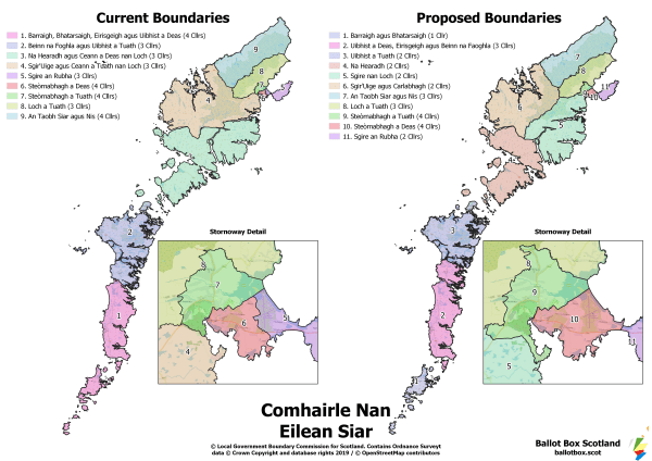
Probably the biggest changes are proposed for the Western Isles. The Boundary Commission is suggesting an increase from 9 to 11 wards, but a decrease from 31 to 28 councillors. Again, it’s worth looking at this as three clusters, each of which is dropping a councillor overall.
Cluster one is Stornoway (Steòrnabhagh) and Point (Sgire an Rubha) – it’d remain three wards, with both of the Stornoway wards expanding geographically but remaining at the four councillors apiece. Point reduces to just the peninsula itself, and is this cluster’s dropped councillor, down to two.
The rest of Lewis (Leòdhas) and Harris (na Hearadh) is split into four wards totalling 13 councillors at the moment. That’d be increased to 5 wards, as Harris gets a 2 councillor ward to itself, leaving the 4 Lewis wards to split the reduced 10 councillors between them. Broad Bay (Loch a Tuath) and West Side & Ness (An Taobh Siar agus Nis) wards are mostly unchanged from their current state, though the latter is where the councillor is lost.
The last cluster is the southern end of the island chain, which is suggested to go from 2 wards with 7 councillors to 3 with 6. The Uists do a trade, with North Uist (Uibhist a Tuath) becoming a 2 member ward by itself by pawning off Benbecula (Beinn na Faoghla) to South Uist (Uibhist a Deas). The latter two islands then form a 3 member ward alongside Eriskay (Eirisgeigh). That leaves Barra (Barraigh) and Vatersay (Bhatarsaigh) together as the only single member ward so far proposed.
Remember that these are only initial proposals. Following the consultation, the Commission will re-assess their proposals in light of responses, and may then revise them and go through a second consultation stage. If you plan to respond to this one, it closes on the 2nd of December. DETAILS FOR RESPONDING HERE.


